


J2 OINGT SGMO 29K

ophness
User
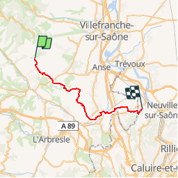

Length
29 km

Max alt
527 m

Uphill gradient
615 m
Km-Effort
38 km

Min alt
185 m

Downhill gradient
886 m
Boucle
No
Creation date :
2019-01-15 16:49:09.827
Updated on :
2019-01-15 16:49:09.827
4h37
Difficulty : Unknown

FREE GPS app for hiking
 SityTrail
IGN / Geographical institutes
SityTrail Plus
The world is yours!
About
Trail Equestrian of 29 km to be discovered at Auvergne-Rhône-Alpes, Rhône, Val d'Oingt. This trail is proposed by ophness.
Positioning
Country:
France
Region :
Auvergne-Rhône-Alpes
Department/Province :
Rhône
Municipality :
Val d'Oingt
Location:
Oingt
Start:(Dec)
Start:(UTM)
622807 ; 5089606 (31T) N.
Comments